this picture makes my brain hurt

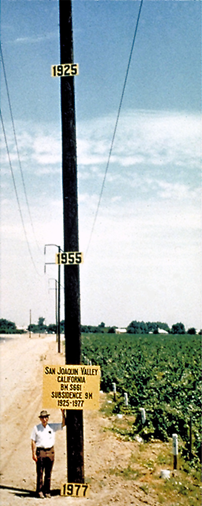
This photo shows the approximate location of maximum subsidence in the United States, identified by research efforts of Dr. Joseph F. Poland (pictured). The site is in the San Joaquin Valley southwest of Mendota, California. Signs on pole show approximate altitude of land surface in 1925, 1955, and 1977.
In this case, excessive groundwater pumping allowed the upper soil layers to dry out and compress and compact, which is by far the single largest cause of subsidence. Soil compaction results in a reduction of the pore sizes between soil particles, resulting in essentially a permanent condition—rewetting of the underground soil and rock does not cause the land to go back up in altitude. This results in a lessening of the total storage capacity of the aquifer system. Here, the term "groundwater mining" is really true.
http://water.usgs.go.....oland.html
would like to see what it is like today
Most Users Ever Online: 698
Currently Online:
50 Guest(s)
Currently Browsing this Page:
1 Guest(s)
Top Posters:
easytapper: 2149
DangerDuke: 2030
groinkick: 1667
PorkChopsMmm: 1515
Gravel Road: 1455
Newest Members:
Forum Stats:
Groups: 1
Forums: 12
Topics: 11482
Posts: 58640
Member Stats:
Guest Posters: 2
Members: 19842
Moderators: 0
Admins: 1
Administrators: K

 Log In
 Home
Home
 Offline


